Groundwater fills the spaces in the rock
Years 7–8 and 11–12Stage 4 and Stage 6Run it
Rain soaks past the roots to the water table. Below it, water moves slowly.
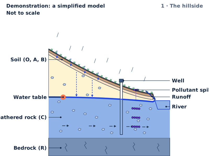
Demonstration: a simplified modelNot to scale1 · The hillside
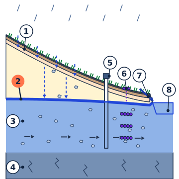
Rain soaks in. Below the water table the rock is full of water, moving slowly to the river. A pollutant has just soaked in.
- Soil (O, A, B)
- Water table
- Weathered rock (C)
- Bedrock (R)
- Well
- Pollutant spill
- Runoff
- River
Key Short slanting lines: rain; more lines for more rain in a year. Dashed arrows: rain soaking into the soil, and on down past the roots to the water table. Thick solid arrows along the ground: runoff. Long-dashed arrows in the rock: the way the groundwater moves. Blue with pieces of rock: rock whose spaces are full of water, below the water table. Dashed line beside the water table: where it lies at the starting settings, for comparison. Purple dots: the pollutant, moving with the groundwater. Brown specks: topsoil washed off; a dotted line marks where the ground was. Arrow from the pump: water pumped out. Blue: water, filling every space between the grains below the water table. Above the water table, a film of water clings to each grain, and air fills the rest.
The model could not start here. The figure, the steps and the table on this page still show the idea; reload the page to try again.
The idea, step by step
Not to scale
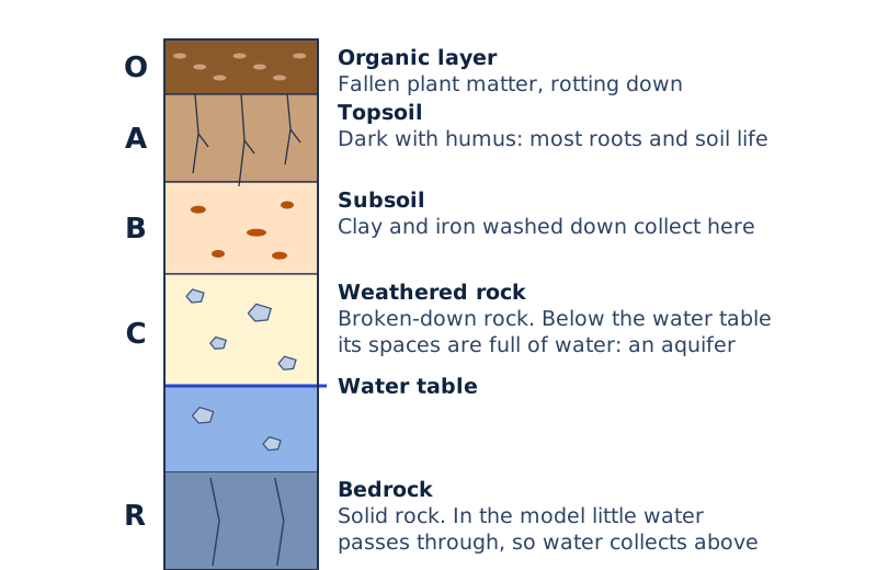
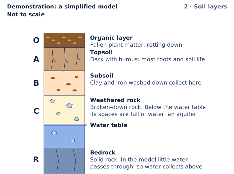
2 · Soil layersDig down: organic layer (O), topsoil (A), subsoil (B), weathered rock (C), then bedrock (R). Each layer holds something different. 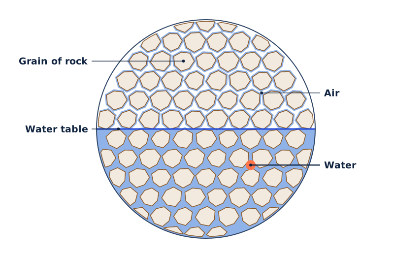
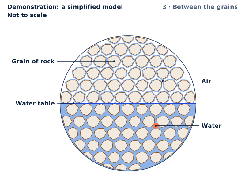
3 · Between the grainsClose up, the water fills the spaces between grains of rock. Groundwater is wet rock, not an underground lake.1 Water table · 2 Grain of rock · 3 Air · 4 Water 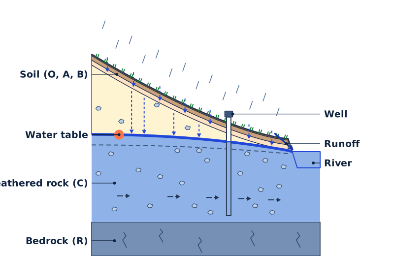
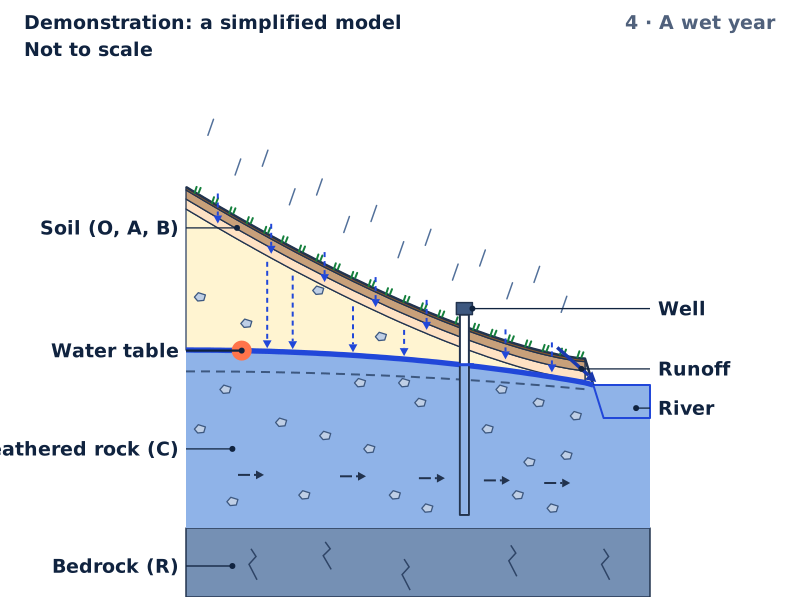
4 · A wet yearMore rain soaks down past the roots and recharges the groundwater. Under the hilltop the water table rises 3.2 m.1 Soil (O, A, B) · 2 Water table · 3 Weathered rock (C) · 4 Bedrock (R) · 5 Well · 6 Runoff · 7 River 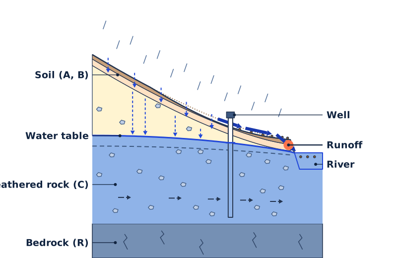
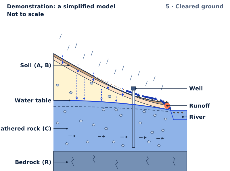
5 · Cleared groundCleared of plants, less rain soaks in and more runs off. Raindrops loosen bare topsoil, and the runoff carries it away.1 Soil (A, B) · 2 Water table · 3 Weathered rock (C) · 4 Bedrock (R) · 5 Well · 6 Runoff · 7 River 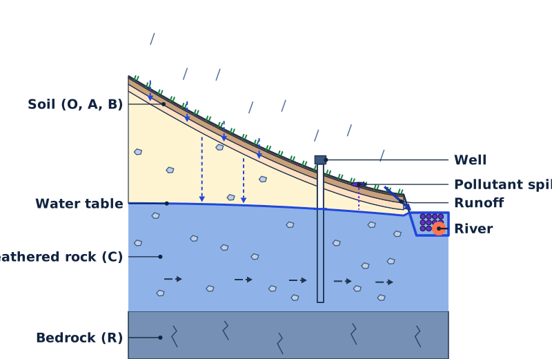
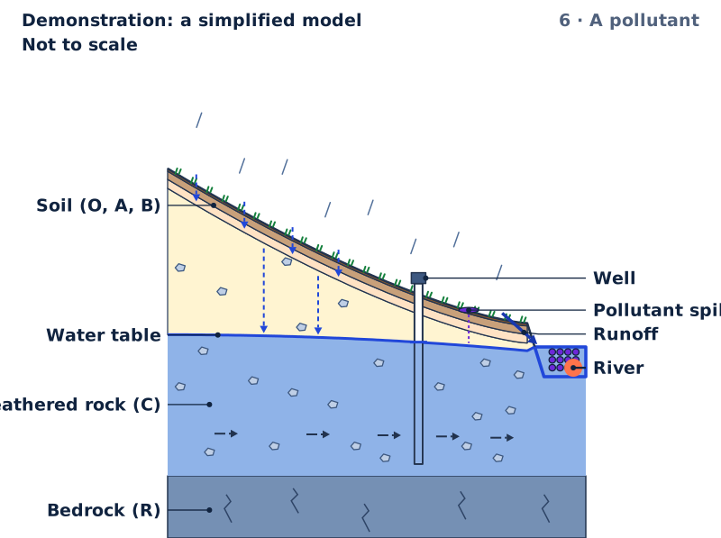
6 · A pollutantA pollutant soaks down to the water table, then moves with the groundwater down the slope, reaching the river after 13 years.1 Soil (O, A, B) · 2 Water table · 3 Weathered rock (C) · 4 Bedrock (R) · 5 Well · 6 Pollutant spill · 7 Runoff · 8 River 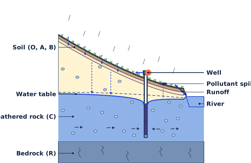
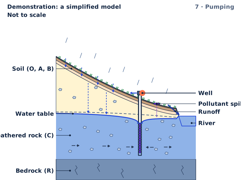
7 · PumpingPumping draws the water table down in a cone around the well. Now the groundwater, and the pollutant, flow into the well.1 Soil (O, A, B) · 2 Water table · 3 Weathered rock (C) · 4 Bedrock (R) · 5 Well · 6 Pollutant spill · 7 Runoff · 8 River


The water table at each rainfall, with the ground cover, pumping and pollutant you chose
| Rain in a year (mm) | Water table below the hilltop (m) | Water table below the ground at the well (m) | Pollutant | In the first figure |
|---|---|---|---|---|
| 200 | 28.7 | 8.0 | just reached the water table | |
| 400 | 27.4 | 7.2 | just reached the water table | |
| 600 | 26.3 | 6.4 | just reached the water table | Shown |
| 800 | 25.1 | 5.6 | just reached the water table | |
| 1000 | 24.1 | 4.8 | just reached the water table | |
| 1200 | 23.0 | 4.1 | just reached the water table |
Try it in the Lab
Practicals with real materials, each with its safety card.
- Aquifer in a tank: water table, wells and a leaking pollutantYear 8Bench practicalLow risk
- Aquifer in a tank: porosity, permeability and a pumped wellYears 7–8Fieldwork and mappingLow risk
- Porosity and permeability of gravel, sand and clayYear 8Bench practicalLow risk
- Ring infiltrometer: how fast water soaks into three surfacesYears 7–8Fieldwork and mappingLow risk
- Porosity and permeability of sand, gravel and clay columns, with Darcy’s lawYear 11Bench practicalLow risk
- Soil erosion prevention: bare, mulched and planted trays under a measured rainfall (syllabus practical)Year 11Bench practicalLow risk
With a learner
Three questions to ask
- Point to the water table. What fills the spaces in the rock just above it, and just below it?
- Why does the water table rise in a wet year, even under the hilltop?
- A fuel tank leaks down the slope from a farm's bore. What should the farmer think about before pumping hard?
What to expect
Many learners picture groundwater as an underground lake, and expect a pollutant to stay where it was spilt or to go only downhill. Step through to the grains, then follow the pollutant with the pump off and on.
What to try next
Open a practical in Try it in the Lab, above: build an aquifer in a tank, pump a well and watch a dye follow the flow.
About this model
What is simplified
- Not to scale: the slice is stretched upwards about thirteen times, and the soil far more than that, so its three layers can be seen. The hilltop is a kilometre from the middle of the river.
- The water table is drawn as it settles for the rain and the pumping you set. A real water table takes months or years to settle after a change, and it rises and falls with the seasons.
- A run shows four years in each second, and the time since the pollutant reached the water table shows on its slider.
- Recharge is a tenth of the rain in a year for both ground covers. Plants take up much of the water that soaks in, and in Australia clearing deep-rooted native plants for pasture or crops has often let more water past the roots and raised water tables. The model does not show that: the cover changes only the runoff, the soaking in and the topsoil washed away.
- The model takes a wetter year to bring more heavy rain, so cleared ground loses more topsoil. Real erosion depends most on how hard the rain falls, and the topsoil lost is drawn far thicker than one year's loss.
- Bedrock in the model lets no water through, so the groundwater collects above it. Real bedrock can hold water and pass it along its cracks.
- Every part of the weathered rock passes water equally well, and the groundwater moves only along the slice. The pollutant is a dozen dots that spread a little as they go; a real pollutant spreads out in every direction, and some of it sticks to the rock or breaks down.
- The run starts when the pollutant reaches the water table. With the pump off, the model lets the pollutant flow on past the well; a real bore it passed would be polluted too.
- The water level in the well is drawn where the water table meets its casing; in a real pumped well it sits a little lower.
- The river keeps the same level however hard the well pumps. Pumping hard near a river can draw river water into the ground towards the well.
- The soil layers view is a sketch of one pit on the hillside, and its water table does not move with the controls. The grains view is enlarged many times.
Numbers and their sources
- 0.0000116 m/s Hydraulic conductivity of the aquifer, the weathered rock and sand below the water table: how easily water passes through it. It is about one metre a day, inside the ranges the source gives for fine sand and for weathered granite. Source: Domenico and Schwartz (1990), Physical and Chemical Hydrogeology, as tabulated in HydroSOLVE (AQTESOLV), Representative Values of Hydraulic Properties: fine sand 2×10⁻⁷ to 2×10⁻⁴ m/s, weathered granite 3.3×10⁻⁶ to 5.2×10⁻⁵ m/s, read 26 September 2026.
- 0.25 Porosity: the fraction of the aquifer that is open space between the grains, where the groundwater is held and moves. The model takes the source's value for sand. Source: Heath, R. C. (1983), Basic Ground-Water Hydrology, U.S. Geological Survey Water-Supply Paper 2220, pp. 7–8, Selected values of porosity: sand 25 percent, read 26 September 2026.
- 0.1 The fraction of the rain in a year that soaks past the roots and reaches the water table (recharge). Across Australia's temperate zones the source finds this fraction from almost none to about a third; the model takes a tenth. Source: Lee, S., Irvine, D. J., Duvert, C., Rau, G. C. and Cartwright, I. (2024), A high-resolution map of diffuse groundwater recharge rates for Australia, Hydrology and Earth System Sciences 28, 1771–1790: median recharge to rainfall ratios in temperate zones from about 0.002 to 0.36, read 26 September 2026.
Review
Demonstration: a simplified model. Checked against its written sources, 26 September 2026. Not reviewed by a qualified teacher.
Curriculum references
SC4-WS-02GE4-2GE4-3GE4-PRI-01EES11-8EES11-11EES-11-03AC9HG7K01
Reference, not a verified alignment.